How a French Military Term Wound Up in North Tuscaloosa County
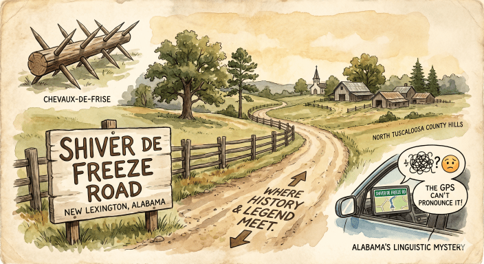
If you’ve ever taken the back roads through the rolling hills of New Lexington in northern Tuscaloosa County, you’ve likely driven past a road sign that makes you do a double-take: Shiver de Freeze Road.
It’s a fantastic, evocative name. It sounds like a vivid description of a bitter, bone-chilling Alabama winter, or perhaps an old family name lost to time. For decades, locals and passersby alike have wondered where on earth the name came from.
In fact, the name remains such a puzzle that even today’s technology doesn’t know what to do with it. If you plug it into Apple Maps, Google Maps, or your car’s built-in navigation system, the robotic automated voice will almost certainly butcher the pronunciation, tying itself in knots trying to read the sign out loud to you.
As it turns out, the story behind Shiver de Freeze Road isn’t about the weather, and it completely confounds modern GPS. It’s a classic piece of Southern folk etymology—a centuries-old French military term that got run through a deep Dixie filter.
The Original “Chevaux-de-Frise”
To understand the name, we have to travel back to 17th-century Europe. The original phrase is chevaux-de-frise (pronounced sheh-VOH-duh-freez), which literally translates from French to “Frisian horses.”
In military history, a cheval-de-frise wasn’t a living animal; it was a brutal defensive obstacle. Picture a massive horizontal wooden log or beam pierced tightly with long, intersecting rows of sharpened wooden stakes or iron spears pointing outward.
Soldiers used these heavy, spiked barriers to block narrow passes, fortify dirt roads, and protect trenches. They were the historical equivalent of razor wire—designed specifically to stop cavalry charges in their tracks and keep infantry from advancing down a roadway.
From French Tactics to Southern Phonetics
So, how did a textbook European military tactic end up on a road sign in rural Alabama?
During the American Revolution and, most notably, the Civil War, both armies relied heavily on these spiked barriers. Because the average 19th-century American soldier didn’t speak fluent French, they spelled the obstacles exactly how they heard them.
In wartime journals and letters home from the 1860s, soldiers frequently wrote about marching past a “shiver de freeze.” It became standard military slang. Even old riddle books from the era poked fun at the term, asking: “Why do rusty iron spikes on a wall remind you of winter? Because they are so often called a ‘shiver de freeze.’”
The Local Legend: Why New Lexington?
While we don’t have a definitive diary entry pointing to the exact day the road was named, historians and locals generally point to two likely origins for our North Tuscaloosa County landmark:
- A Civil War Roadblock: In the spring of 1865, Union General John Croxton led a cavalry raid straight through northern Tuscaloosa County to burn the University of Alabama. Local home guards and retreating Confederate forces frequently threw up makeshift chevaux-de-frise—using lopped pine trees, sharpened branches, and old fence rails—to block rural ridges and river approaches to slow down the Union advance. If a prominent barrier was constructed across this specific stretch of ridge, the name “Shiver de Freeze” would have stuck to that dirt forever.
- A Metaphor for the Terrain: Rural old-timers were incredibly descriptive when naming roads. If a particular stretch of road was brutally difficult to travel—perhaps bounded by jagged limestone outcrops, dense briars, or sharp, jagged cedar thickets—locals might have remarked that navigating it was like trying to pick your way through a shiver de freeze.
A Living Piece of History
Over the generations, as the old military tactics faded from living memory, the phonetic spelling was officially preserved on the county maps.
Today, Shiver de Freeze Road stands as a brilliant linguistic footprint. It’s a reminder of how global history, wartime language, and the distinct rhythm of the Southern accent can come together to leave a permanent mark on the landscape we drive through every day.
The next time you’re out near New Lexington and your car’s GPS starts fumbling over the directions, just smile. You’re driving past a piece of history that a smartphone still can’t quite map out.
